
Check out this article from The Journal of Chemical Education to read about the history of R. Here is an alternate link in case you do not have access to the journal.
Check out this article from The Journal of Chemical Education to read about the history of R. Here is an alternate link in case you do not have access to the journal.
What happens to easterly waves during and after a tropical cyclone (TC) forms? How does their potential vorticity (PV) field evolve? This observational study led by graduate student Bryce Tyner examines the PV associated with easterly waves during the process of TC genesis.
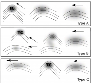 Qualitatively, three types of evolution were defined. First, the most common one in which the wave PV axisymmetrizes and gets completely wrapped up into the TC. Second, less often, the TC cuts-off from the wave and the wave continues on. Third, rather rare, in which the the wave and the cyclone appear to co-exist. This may happen for a weak TC which goes from a wave to a TC and back to an “open wave”.
For more information, see the paper: Tyner and Aiyyer, 2013
About a third of all tropical cyclones recurve in the western Pacific. Often these recurving cyclones also undergo extratropical transition (ET). As documented in numerous studies, the process of cyclone recurvature and ET involves the interaction of the tropical cyclone with the midlatitude flow field. The interaction “excites” a Rossby wave packet downstream of the recurvature location. As a result, the tropical cyclone can indirectly influence the weather at a far away location through the action of this developing wavepacket. The predictive skill of operational weather forecast models is often degraded in the downstream location because they do not adequately capture the details of the TC-midlatitude flow interaction and the evolution of the wave packet.
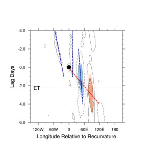
Developing wave packet downstream of a recurving typhoons: Hovmoller Diagram showing a composite 500-hpa height anomaly field relative to the position of recurvature (marked by the hurricane symbol). Data: ERA-interim reanalysis. Composite using data for 146 Western North Pacific cylcones.
Some pertinent questions can be asked: (1) Does tropical cyclone recurvature significantly add to the loss of forecast skill over-and-above what is expected from the inherent loss of skill for longer lead times? (2) How fast do the errors grow and how much of the downstream area is impacted?
An ensemble prediction system with data from a large number of tropical cyclone cases is ideal to answer these questions. In Aiyyer (2015), we use data from NOAA’s 2nd generation reforecasts and considered 146 western North Pacific recurving typhoons. We define model skill using the ensemble spread (this is just the standard deviation of data from all ensemble members). To get a sense of skill loss relative to the model’s baseline loss (that is the expected loss of skill as forecast lead time increases), we divide the ensemble spread for each hour by the climatological spread for that hour (climatology calculated using forecast data from 1985-2013). We called this normalized spread.
The key results from this paper are: